
Départ du Pont · Alpes, Val d'Aoste, Parc National du Grand Paradis, IT · GPS 45°31'30.77'' N 7°11'31.50'' E · Altitude 2096m
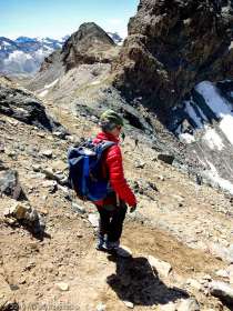
2019-08-14 · 07:45 · Taou Blanc (Mont Tout Blanc)

Départ du Pont · Alpes, Val d'Aoste, Parc National du Grand Paradis, IT · GPS 45°31'30.51'' N 7°11'30.79'' E · Altitude 2100m
2019-08-14 · 07:46 · Taou Blanc (Mont Tout Blanc)

Croix d'Arroley · Alpes, Val d'Aoste, Parc National du Grand Paradis, IT · GPS 45°31'28.92'' N 7°11'20.08'' E · Altitude 2297m
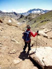
2019-08-14 · 08:05 · Taou Blanc (Mont Tout Blanc)

Dans le Vallon du Nivolet · Alpes, Val d'Aoste, Parc National du Grand Paradis, IT · GPS 45°31'29.07'' N 7°11'20.13'' E · Altitude 2299m
2019-08-14 · 08:06 · Taou Blanc (Mont Tout Blanc)

Dans le Vallon du Nivolet · Alpes, Val d'Aoste, Parc National du Grand Paradis, IT · GPS 45°31'19.26'' N 7°10'58.39'' E · Altitude 2356m
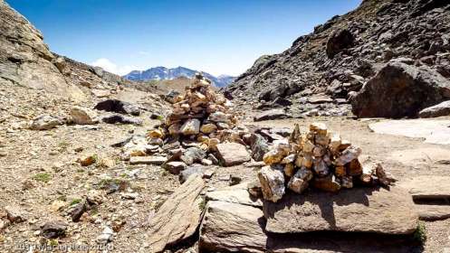
2019-08-14 · 08:20 · Taou Blanc (Mont Tout Blanc)

Dans le Vallon du Nivolet · Alpes, Val d'Aoste, Parc National du Grand Paradis, IT · GPS 45°31'16.67'' N 7°10'55.40'' E · Altitude 2356m
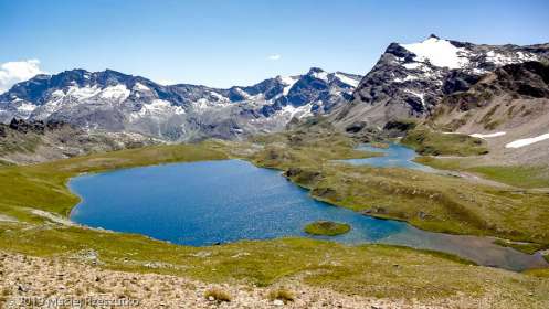
2019-08-14 · 08:22 · Taou Blanc (Mont Tout Blanc)

Dans le Vallon du Nivolet · Alpes, Val d'Aoste, Parc National du Grand Paradis, IT · GPS 45°31'2.40'' N 7°10'43.51'' E · Altitude 2379m
2019-08-14 · 08:30 · Taou Blanc (Mont Tout Blanc)

Dans le Vallon du Nivolet · Alpes, Val d'Aoste, Parc National du Grand Paradis, IT · GPS 45°30'16.23'' N 7°10'1.56'' E · Altitude 2393m
2019-08-14 · 08:50 · Taou Blanc (Mont Tout Blanc)

Dans le Vallon du Nivolet · Alpes, Val d'Aoste, Parc National du Grand Paradis, IT · GPS 45°30'16.13'' N 7°10'1.22'' E · Altitude 2397m
2019-08-14 · 08:50 · Taou Blanc (Mont Tout Blanc)

Dans le Vallon du Nivolet · Alpes, Val d'Aoste, Parc National du Grand Paradis, IT · GPS 45°30'15.07'' N 7°9'59.71'' E · Altitude 2404m
2019-08-14 · 08:52 · Taou Blanc (Mont Tout Blanc)

Dans le Vallon du Nivolet · Alpes, Val d'Aoste, Parc National du Grand Paradis, IT · GPS 45°30'14.30'' N 7°9'58.56'' E · Altitude 2403m
2019-08-14 · 08:52 · Taou Blanc (Mont Tout Blanc)

Refuge de Savoie · Alpes, Val d'Aoste, Parc National du Grand Paradis, IT · GPS 45°29'10.07'' N 7°8'38.12'' E · Altitude 2507m
2019-08-14 · 09:24 · Taou Blanc (Mont Tout Blanc)

Montée au Col Leynir · Alpes, Val d'Aoste, Parc National du Grand Paradis, IT · GPS 45°29'15.34'' N 7°8'34.81'' E · Altitude 2553m
2019-08-14 · 09:30 · Taou Blanc (Mont Tout Blanc)

Montée au Col Leynir · Alpes, Val d'Aoste, Parc National du Grand Paradis, IT · GPS 45°29'13.61'' N 7°8'28.58'' E · Altitude 2594m
2019-08-14 · 09:35 · Taou Blanc (Mont Tout Blanc)

Montée au Col Leynir · Alpes, Val d'Aoste, Parc National du Grand Paradis, IT · GPS 45°29'50.44'' N 7°8'29.18'' E · Altitude 2712m
2019-08-14 · 09:53 · Taou Blanc (Mont Tout Blanc)

Montée au Col Leynir · Alpes, Val d'Aoste, Parc National du Grand Paradis, IT · GPS 45°30'3.70'' N 7°8'25.06'' E · Altitude 2748m
2019-08-14 · 10:02 · Taou Blanc (Mont Tout Blanc)

Montée au Col Leynir · Alpes, Val d'Aoste, Parc National du Grand Paradis, IT · GPS 45°30'5.30'' N 7°8'17.50'' E · Altitude 2795m
2019-08-14 · 10:07 · Taou Blanc (Mont Tout Blanc)

Montée au Col Leynir · Alpes, Val d'Aoste, Parc National du Grand Paradis, IT · GPS 45°30'14.69'' N 7°8'28.20'' E · Altitude 2854m
2019-08-14 · 10:16 · Taou Blanc (Mont Tout Blanc)

Montée au Col Leynir · Alpes, Val d'Aoste, Parc National du Grand Paradis, IT · GPS 45°30'20.49'' N 7°8'27.44'' E · Altitude 2877m
2019-08-14 · 10:21 · Taou Blanc (Mont Tout Blanc)

Montée au Col Leynir · Alpes, Val d'Aoste, Parc National du Grand Paradis, IT · GPS 45°30'25.76'' N 7°8'34.00'' E · Altitude 2882m
2019-08-14 · 10:24 · Taou Blanc (Mont Tout Blanc)

Montée au Col Leynir · Alpes, Val d'Aoste, Parc National du Grand Paradis, IT · GPS 45°30'36.31'' N 7°8'31.45'' E · Altitude 2909m
2019-08-14 · 10:30 · Taou Blanc (Mont Tout Blanc)

Montée au Col Leynir · Alpes, Val d'Aoste, Parc National du Grand Paradis, IT · GPS 45°30'36.93'' N 7°8'31.13'' E · Altitude 2909m
2019-08-14 · 10:31 · Taou Blanc (Mont Tout Blanc)

Montée au Col Leynir · Alpes, Val d'Aoste, Parc National du Grand Paradis, IT · GPS 45°30'39.54'' N 7°8'32.16'' E · Altitude 2904m
2019-08-14 · 10:32 · Taou Blanc (Mont Tout Blanc)

Montée au Col Leynir · Alpes, Val d'Aoste, Parc National du Grand Paradis, IT · GPS 45°30'59.92'' N 7°8'37.69'' E · Altitude 2994m
2019-08-14 · 10:49 · Taou Blanc (Mont Tout Blanc)

Montée au Col Leynir · Alpes, Val d'Aoste, Parc National du Grand Paradis, IT · GPS 45°31'1.33'' N 7°8'35.56'' E · Altitude 3031m
2019-08-14 · 10:53 · Taou Blanc (Mont Tout Blanc)

Au Col Leynir · Alpes, Val d'Aoste, Parc National du Grand Paradis, IT · GPS 45°31'5.56'' N 7°8'24.45'' E · Altitude 3053m
2019-08-14 · 11:00 · Taou Blanc (Mont Tout Blanc)

Au Col Leynir · Alpes, Val d'Aoste, Parc National du Grand Paradis, IT · GPS 45°31'5.58'' N 7°8'24.42'' E · Altitude 3053m
2019-08-14 · 11:01 · Taou Blanc (Mont Tout Blanc)

Au Col Leynir · Alpes, Val d'Aoste, Parc National du Grand Paradis, IT · GPS 45°31'5.68'' N 7°8'24.33'' E · Altitude 3054m
2019-08-14 · 11:01 · Taou Blanc (Mont Tout Blanc)

Au Col Leynir · Alpes, Val d'Aoste, Parc National du Grand Paradis, IT · GPS 45°31'5.87'' N 7°8'24.38'' E · Altitude 3055m
2019-08-14 · 11:02 · Taou Blanc (Mont Tout Blanc)

Au Col Leynir · Alpes, Val d'Aoste, Parc National du Grand Paradis, IT · GPS 45°31'8.16'' N 7°8'25.00'' E · Altitude 3074m
2019-08-14 · 11:07 · Taou Blanc (Mont Tout Blanc)

Au Col Leynir · Alpes, Val d'Aoste, Parc National du Grand Paradis, IT · GPS 45°31'10.22'' N 7°8'22.87'' E · Altitude 3066m
2019-08-14 · 11:10 · Taou Blanc (Mont Tout Blanc)

Au Col Leynir · Alpes, Val d'Aoste, Parc National du Grand Paradis, IT · GPS 45°31'10.40'' N 7°8'22.65'' E · Altitude 3066m
2019-08-14 · 11:11 · Taou Blanc (Mont Tout Blanc)

Dernière pente avant le sommet · Alpes, Val d'Aoste, Parc National du Grand Paradis, IT · GPS 45°31'9.16'' N 7°8'27.89'' E · Altitude 3120m
2019-08-14 · 11:17 · Taou Blanc (Mont Tout Blanc)

Dernière pente avant le sommet · Alpes, Val d'Aoste, Parc National du Grand Paradis, IT · GPS 45°31'9.13'' N 7°8'27.98'' E · Altitude 3120m
2019-08-14 · 11:17 · Taou Blanc (Mont Tout Blanc)

Dernière pente avant le sommet · Alpes, Val d'Aoste, Parc National du Grand Paradis, IT · GPS 45°31'9.22'' N 7°8'28.12'' E · Altitude 3124m
2019-08-14 · 11:18 · Taou Blanc (Mont Tout Blanc)


Dernière pente avant le sommet · Alpes, Val d'Aoste, Parc National du Grand Paradis, IT · GPS 45°31'11.47'' N 7°8'29.62'' E · Altitude 3150m
2019-08-14 · 11:21 · Taou Blanc (Mont Tout Blanc)

Dernière pente avant le sommet · Alpes, Val d'Aoste, Parc National du Grand Paradis, IT · GPS 45°31'13.35'' N 7°8'33.00'' E · Altitude 3181m
2019-08-14 · 11:24 · Taou Blanc (Mont Tout Blanc)

Dernière pente avant le sommet · Alpes, Val d'Aoste, Parc National du Grand Paradis, IT · GPS 45°31'14.70'' N 7°8'47.27'' E · Altitude 3281m
2019-08-14 · 11:35 · Taou Blanc (Mont Tout Blanc)

Dernière pente avant le sommet · Alpes, Val d'Aoste, Parc National du Grand Paradis, IT · GPS 45°31'14.70'' N 7°8'47.37'' E · Altitude 3283m
2019-08-14 · 11:35 · Taou Blanc (Mont Tout Blanc)

Dernière pente avant le sommet · Alpes, Val d'Aoste, Parc National du Grand Paradis, IT · GPS 45°31'20.15'' N 7°8'52.62'' E · Altitude 3438m
2019-08-14 · 11:48 · Taou Blanc (Mont Tout Blanc)

Grand Paradis depuis le sommet · Alpes, Val d'Aoste, Parc National du Grand Paradis, IT · GPS 45°31'20.14'' N 7°8'52.65'' E · Altitude 3438m
2019-08-14 · 11:48 · Taou Blanc (Mont Tout Blanc)

Grand Paradis depuis le sommet · Alpes, Val d'Aoste, Parc National du Grand Paradis, IT · GPS 45°31'20.14'' N 7°8'52.65'' E · Altitude 3438m
2019-08-14 · 11:48 · Taou Blanc (Mont Tout Blanc)

Valais en Suisse depuis le sommet · Alpes, Val d'Aoste, Parc National du Grand Paradis, IT · GPS 45°31'20.14'' N 7°8'52.65'' E · Altitude 3438m
2019-08-14 · 11:48 · Taou Blanc (Mont Tout Blanc)

Massif du Mont Blanc depuis le sommet · Alpes, Val d'Aoste, Parc National du Grand Paradis, IT · GPS 45°31'20.15'' N 7°8'52.65'' E · Altitude 3438m
2019-08-14 · 11:49 · Taou Blanc (Mont Tout Blanc)

Vue depuis le sommet · Alpes, Val d'Aoste, Parc National du Grand Paradis, IT · GPS 45°31'20.14'' N 7°8'52.65'' E · Altitude 3438m
2019-08-14 · 11:49 · Taou Blanc (Mont Tout Blanc)

Arrivé au sommet · Alpes, Val d'Aoste, Parc National du Grand Paradis, IT · GPS 45°31'20.14'' N 7°8'52.63'' E · Altitude 3438m
2019-08-14 · 11:49 · Taou Blanc (Mont Tout Blanc)

Arrivé au sommet · Alpes, Val d'Aoste, Parc National du Grand Paradis, IT · GPS 45°31'20.14'' N 7°8'52.63'' E · Altitude 3438m
2019-08-14 · 11:49 · Taou Blanc (Mont Tout Blanc)

Vue depuis le sommet du Taou Blanc · Alpes, Val d'Aoste, Parc National du Grand Paradis, IT · GPS 45°31'20.14'' N 7°8'52.65'' E · Altitude 3438m
2019-08-14 · 11:50 · Taou Blanc (Mont Tout Blanc)

Vue depuis le sommet du Taou Blanc · Alpes, Val d'Aoste, Parc National du Grand Paradis, IT · GPS 45°31'20.13'' N 7°8'52.66'' E · Altitude 3438m
2019-08-14 · 11:50 · Taou Blanc (Mont Tout Blanc)

Vue depuis le sommet du Taou Blanc · Alpes, Val d'Aoste, Parc National du Grand Paradis, IT · GPS 45°31'20.14'' N 7°8'52.65'' E · Altitude 3438m
2019-08-14 · 11:51 · Taou Blanc (Mont Tout Blanc)

Au sommet du Taou Blanc · Alpes, Val d'Aoste, Parc National du Grand Paradis, IT · GPS 45°31'20.17'' N 7°8'52.64'' E · Altitude 3438m
2019-08-14 · 12:04 · Taou Blanc (Mont Tout Blanc)

Grand Paradis depuis le sommet · Alpes, Val d'Aoste, Parc National du Grand Paradis, IT · GPS 45°31'20.13'' N 7°8'52.63'' E · Altitude 3438m
2019-08-14 · 12:16 · Taou Blanc (Mont Tout Blanc)

Au sommet du Taou Blanc · Alpes, Val d'Aoste, Parc National du Grand Paradis, IT · GPS 45°31'20.12'' N 7°8'52.62'' E · Altitude 3438m
2019-08-14 · 12:20 · Taou Blanc (Mont Tout Blanc)

Au sommet du Taou Blanc - Mont Blanc derrière · Alpes, Val d'Aoste, Parc National du Grand Paradis, IT · GPS 45°31'20.11'' N 7°8'52.62'' E · Altitude 3438m
2019-08-14 · 12:22 · Taou Blanc (Mont Tout Blanc)

Descente du sommet de Taou Blanc · Alpes, Val d'Aoste, Parc National du Grand Paradis, IT · GPS 45°31'19.85'' N 7°8'52.64'' E · Altitude 3438m
2019-08-14 · 12:25 · Taou Blanc (Mont Tout Blanc)

Descente du sommet de Taou Blanc · Alpes, Val d'Aoste, Parc National du Grand Paradis, IT · GPS 45°31'19.84'' N 7°8'52.65'' E · Altitude 3438m
2019-08-14 · 12:25 · Taou Blanc (Mont Tout Blanc)

Vue depuis le sommet du Taou Blanc · Alpes, Val d'Aoste, Parc National du Grand Paradis, IT · GPS 45°31'17.80'' N 7°8'54.92'' E · Altitude 3438m
2019-08-14 · 12:28 · Taou Blanc (Mont Tout Blanc)

Vue depuis le sommet du Taou Blanc · Alpes, Val d'Aoste, Parc National du Grand Paradis, IT · GPS 45°31'17.83'' N 7°8'54.91'' E · Altitude 3438m
2019-08-14 · 12:28 · Taou Blanc (Mont Tout Blanc)

Vue depuis le sommet du Taou Blanc · Alpes, Val d'Aoste, Parc National du Grand Paradis, IT · GPS 45°31'17.81'' N 7°8'54.91'' E · Altitude 3438m
2019-08-14 · 12:29 · Taou Blanc (Mont Tout Blanc)

Massif du Grand Paradis depuis le sommet · Alpes, Val d'Aoste, Parc National du Grand Paradis, IT · GPS 45°31'17.78'' N 7°8'54.90'' E · Altitude 3438m
2019-08-14 · 12:31 · Taou Blanc (Mont Tout Blanc)

Vue depuis le sommet du Taou Blanc · Alpes, Val d'Aoste, Parc National du Grand Paradis, IT · GPS 45°31'17.90'' N 7°8'54.93'' E · Altitude 3438m
2019-08-14 · 12:32 · Taou Blanc (Mont Tout Blanc)

Vue depuis le sommet du Taou Blanc · Alpes, Val d'Aoste, Parc National du Grand Paradis, IT · GPS 45°31'17.77'' N 7°8'54.84'' E · Altitude 3438m
2019-08-14 · 12:33 · Taou Blanc (Mont Tout Blanc)

Valais en Suisse depuis le sommet · Alpes, Val d'Aoste, Parc National du Grand Paradis, IT · GPS 45°31'18.23'' N 7°8'54.36'' E · Altitude 3438m
2019-08-14 · 12:35 · Taou Blanc (Mont Tout Blanc)

Descente au Col Leynir · Alpes, Val d'Aoste, Parc National du Grand Paradis, IT · GPS 45°31'18.33'' N 7°8'54.24'' E · Altitude 3438m
2019-08-14 · 12:35 · Taou Blanc (Mont Tout Blanc)

Descente au Col Leynir · Alpes, Val d'Aoste, Parc National du Grand Paradis, IT · GPS 45°31'12.91'' N 7°8'32.37'' E · Altitude 3184m
2019-08-14 · 12:46 · Taou Blanc (Mont Tout Blanc)

Descente au Col Leynir · Alpes, Val d'Aoste, Parc National du Grand Paradis, IT · GPS 45°31'9.41'' N 7°8'27.43'' E · Altitude 3121m
2019-08-14 · 12:49 · Taou Blanc (Mont Tout Blanc)

Descente au Col Leynir · Alpes, Val d'Aoste, Parc National du Grand Paradis, IT · GPS 45°31'9.47'' N 7°8'27.40'' E · Altitude 3121m
2019-08-14 · 12:50 · Taou Blanc (Mont Tout Blanc)

Descente au Col Leynir · Alpes, Val d'Aoste, Parc National du Grand Paradis, IT · GPS 45°31'9.62'' N 7°8'27.20'' E · Altitude 3119m
2019-08-14 · 12:50 · Taou Blanc (Mont Tout Blanc)

Descente au Col Leynir · Alpes, Val d'Aoste, Parc National du Grand Paradis, IT · GPS 45°31'9.80'' N 7°8'25.72'' E · Altitude 3092m
2019-08-14 · 12:53 · Taou Blanc (Mont Tout Blanc)

Descente au Col Leynir · Alpes, Val d'Aoste, Parc National du Grand Paradis, IT · GPS 45°31'9.69'' N 7°8'25.61'' E · Altitude 3090m
2019-08-14 · 12:53 · Taou Blanc (Mont Tout Blanc)

Descente au Col Leynir · Alpes, Val d'Aoste, Parc National du Grand Paradis, IT · GPS 45°31'9.35'' N 7°8'25.41'' E · Altitude 3086m
2019-08-14 · 12:54 · Taou Blanc (Mont Tout Blanc)

Vue sur le Val de Rhêmes · Alpes, Val d'Aoste, Parc National du Grand Paradis, IT · GPS 45°31'10.31'' N 7°8'22.61'' E · Altitude 3066m
2019-08-14 · 12:55 · Taou Blanc (Mont Tout Blanc)

Vue depuis le Col Leynir · Alpes, Val d'Aoste, Parc National du Grand Paradis, IT · GPS 45°31'4.99'' N 7°8'24.54'' E · Altitude 3046m
2019-08-14 · 13:06 · Taou Blanc (Mont Tout Blanc)

Vue depuis le Col Leynir · Alpes, Val d'Aoste, Parc National du Grand Paradis, IT · GPS 45°31'4.70'' N 7°8'24.44'' E · Altitude 3047m
2019-08-14 · 13:06 · Taou Blanc (Mont Tout Blanc)

Col Leynir · Alpes, Val d'Aoste, Parc National du Grand Paradis, IT · GPS 45°31'4.42'' N 7°8'24.45'' E · Altitude 3047m
2019-08-14 · 13:06 · Taou Blanc (Mont Tout Blanc)

Au Col Leynir · Alpes, Val d'Aoste, Parc National du Grand Paradis, IT · GPS 45°31'4.31'' N 7°8'28.46'' E · Altitude 3042m
2019-08-14 · 13:10 · Taou Blanc (Mont Tout Blanc)

Au Col Leynir · Alpes, Val d'Aoste, Parc National du Grand Paradis, IT · GPS 45°31'4.31'' N 7°8'28.46'' E · Altitude 3042m
2019-08-14 · 13:11 · Taou Blanc (Mont Tout Blanc)

Retour au Col du Nivolet · Alpes, Val d'Aoste, Parc National du Grand Paradis, IT · GPS 45°30'55.88'' N 7°8'29.68'' E · Altitude 2946m
2019-08-14 · 13:34 · Taou Blanc (Mont Tout Blanc)

Retour au Col du Nivolet · Alpes, Val d'Aoste, Parc National du Grand Paradis, IT · GPS 45°30'45.76'' N 7°8'36.41'' E · Altitude 2885m
2019-08-14 · 13:39 · Taou Blanc (Mont Tout Blanc)

Retour au Col du Nivolet · Alpes, Val d'Aoste, Parc National du Grand Paradis, IT · GPS 45°30'37.70'' N 7°8'31.38'' E · Altitude 2905m
2019-08-14 · 13:46 · Taou Blanc (Mont Tout Blanc)

Retour au Col du Nivolet · Alpes, Val d'Aoste, Parc National du Grand Paradis, IT · GPS 45°30'30.31'' N 7°8'33.01'' E · Altitude 2889m
2019-08-14 · 13:50 · Taou Blanc (Mont Tout Blanc)

Au dessus du Lac Rosset · Alpes, Val d'Aoste, Parc National du Grand Paradis, IT · GPS 45°30'5.71'' N 7°8'17.21'' E · Altitude 2794m
2019-08-14 · 14:02 · Taou Blanc (Mont Tout Blanc)

Retour au Col du Nivolet · Alpes, Val d'Aoste, Parc National du Grand Paradis, IT · GPS 45°30'2.97'' N 7°8'3.75'' E · Altitude 2748m
2019-08-14 · 14:08 · Taou Blanc (Mont Tout Blanc)

Retour au Col du Nivolet · Alpes, Val d'Aoste, Parc National du Grand Paradis, IT · GPS 45°30'2.90'' N 7°8'3.06'' E · Altitude 2745m
2019-08-14 · 14:08 · Taou Blanc (Mont Tout Blanc)

Retour au Col du Nivolet · Alpes, Val d'Aoste, Parc National du Grand Paradis, IT · GPS 45°29'57.90'' N 7°7'51.26'' E · Altitude 2752m
2019-08-14 · 14:17 · Taou Blanc (Mont Tout Blanc)

Retour au Col du Nivolet · Alpes, Val d'Aoste, Parc National du Grand Paradis, IT · GPS 45°29'42.42'' N 7°8'8.00'' E · Altitude 2675m
2019-08-14 · 14:29 · Taou Blanc (Mont Tout Blanc)

Lac Rosset · Alpes, Val d'Aoste, Parc National du Grand Paradis, IT · GPS 45°29'42.26'' N 7°8'9.68'' E · Altitude 2678m
2019-08-14 · 14:30 · Taou Blanc (Mont Tout Blanc)

Lac Rosset · Alpes, Val d'Aoste, Parc National du Grand Paradis, IT · GPS 45°29'42.27'' N 7°8'9.83'' E · Altitude 2677m
2019-08-14 · 14:31 · Taou Blanc (Mont Tout Blanc)

Retour au Col du Nivolet · Alpes, Val d'Aoste, Parc National du Grand Paradis, IT · GPS 45°29'42.25'' N 7°8'9.82'' E · Altitude 2677m
2019-08-14 · 14:31 · Taou Blanc (Mont Tout Blanc)

Lac Rosset · Alpes, Val d'Aoste, Parc National du Grand Paradis, IT · GPS 45°29'41.03'' N 7°8'10.75'' E · Altitude 2676m
2019-08-14 · 14:34 · Taou Blanc (Mont Tout Blanc)

Retour au Col du Nivolet · Alpes, Val d'Aoste, Parc National du Grand Paradis, IT · GPS 45°29'28.42'' N 7°8'1.25'' E · Altitude 2662m
2019-08-14 · 14:42 · Taou Blanc (Mont Tout Blanc)

Retour au Col du Nivolet · Alpes, Val d'Aoste, Parc National du Grand Paradis, IT · GPS 45°29'12.51'' N 7°8'15.33'' E · Altitude 2598m
2019-08-14 · 14:53 · Taou Blanc (Mont Tout Blanc)

Retour au Col du Nivolet · Alpes, Val d'Aoste, Parc National du Grand Paradis, IT · GPS 45°29'10.18'' N 7°8'19.80'' E · Altitude 2592m
2019-08-14 · 14:56 · Taou Blanc (Mont Tout Blanc)

Retour au Col du Nivolet · Alpes, Val d'Aoste, Parc National du Grand Paradis, IT · GPS 45°29'9.80'' N 7°8'21.17'' E · Altitude 2592m
2019-08-14 · 14:57 · Taou Blanc (Mont Tout Blanc)

Retour au Col du Nivolet · Alpes, Val d'Aoste, Parc National du Grand Paradis, IT · GPS 45°29'9.63'' N 7°8'21.30'' E · Altitude 2591m
2019-08-14 · 14:58 · Taou Blanc (Mont Tout Blanc)

Retour au Col du Nivolet · Alpes, Val d'Aoste, Parc National du Grand Paradis, IT · GPS 45°29'9.70'' N 7°8'21.46'' E · Altitude 2590m
2019-08-14 · 14:59 · Taou Blanc (Mont Tout Blanc)

Retour au Col du Nivolet · Alpes, Val d'Aoste, Parc National du Grand Paradis, IT · GPS 45°28'53.11'' N 7°8'31.32'' E · Altitude 2539m
2019-08-14 · 15:08 · Taou Blanc (Mont Tout Blanc)

Retour au Col du Nivolet · Alpes, Val d'Aoste, Parc National du Grand Paradis, IT · GPS 45°29'0.33'' N 7°8'36.89'' E · Altitude 2518m
2019-08-14 · 15:12 · Taou Blanc (Mont Tout Blanc)

Retour au Col du Nivolet · Alpes, Val d'Aoste, Parc National du Grand Paradis, IT · GPS 45°29'8.37'' N 7°8'36.46'' E · Altitude 2510m
2019-08-14 · 15:15 · Taou Blanc (Mont Tout Blanc)

Vue sur le Massif du Grand Paradis · Alpes, Val d'Aoste, Parc National du Grand Paradis, IT · GPS 45°31'23.97'' N 7°10'40.46'' E · Altitude 2491m
2019-08-14 · 16:29 · Taou Blanc (Mont Tout Blanc)

Vue sur le Massif du Grand Paradis · Alpes, Val d'Aoste, Parc National du Grand Paradis, IT · GPS 45°31'28.75'' N 7°10'45.30'' E · Altitude 2477m
2019-08-14 · 16:36 · Taou Blanc (Mont Tout Blanc)

Vue sur le Massif du Grand Paradis · Alpes, Val d'Aoste, Parc National du Grand Paradis, IT · GPS 45°31'31.58'' N 7°10'51.68'' E · Altitude 2464m
2019-08-14 · 16:40 · Taou Blanc (Mont Tout Blanc)

Vue sur le Massif du Grand Paradis · Alpes, Val d'Aoste, Parc National du Grand Paradis, IT · GPS 45°31'31.57'' N 7°10'51.71'' E · Altitude 2465m
2019-08-14 · 16:41 · Taou Blanc (Mont Tout Blanc)

Vue sur le Massif du Grand Paradis · Alpes, Val d'Aoste, Parc National du Grand Paradis, IT · GPS 45°31'31.58'' N 7°10'51.71'' E · Altitude 2465m
2019-08-14 · 16:42 · Taou Blanc (Mont Tout Blanc)

Vue sur le Massif du Grand Paradis · Alpes, Val d'Aoste, Parc National du Grand Paradis, IT · GPS 45°31'31.58'' N 7°10'51.71'' E · Altitude 2465m
2019-08-14 · 16:42 · Taou Blanc (Mont Tout Blanc)